Maison de Thoules
Selected walks
Walks and hikes selected by us around Thoules and throughout the Valpelline valley.
Back to surroundingsWe recommend downloading a hiking app (for example Europe 3D or Komoot) showing the main trails in the area with georeferenced positioning.
Easy walks are shown in green, medium-difficulty walks in yellow, and the more demanding routes in red.
Maison de Thoules
List of walks
| Name | Difficulty | Distance | Elevation gain | Time |
|---|---|---|---|---|
| Prarayer Dam | Easy | 5.5 km | 200 m | 2 h 20 (one way) |
| Abbé Henry Loop | Easy | 6.7 km | 300 m | 3 h |
| Lower Verzignolettaz Loop | Easy | 3 km | 254 m | 1 h 30 |
| Arpisson–Verzignolettaz Upper Loop | Medium | 8.6 km | 1050 m | 4 h 30 |
| Arpisson–Fouillou High Loop | Hard | 16.14 km | 1819 m | 8 h |
| Ru du Mont (from the house) | Medium | 14 km | 1000 m | 6 h |
| Ru du Mont (from the Fontina House) | Easy | 6 km | 480 m | 2 h 50 |
| Champillon Refuge | Easy | 3 km | 380 m | 1 h 30 (one way) |
| Ru de By from Champillon | Easy | 9.8 km max | 250 m | 5 h max |
| Lac Mort | Hard | 5 km | 754 m | 2 h 30 (one way) |
| Thoules–Oyace Loop | Medium | 8 km | 600 m | 3 h 30 |
| Col Bruson | Hard | 5.5 km | 1200 m | 3 h 30 (one way) |
| Crête Sèche Refuge | Medium | 3 km | 689 m | 2 h 30 (one way) |
| Chaligne Refuge | Medium | 3.2 km | 400 m | 1 h 40 (one way) |
| Frassati Refuge | Hard | 7.2 km | 500 m | 3 h 45 (one way) |
| Bionaz Mines Loop | Easy | 2.5 km | 150 m | 1 h 20 (one way) |
01
Easy
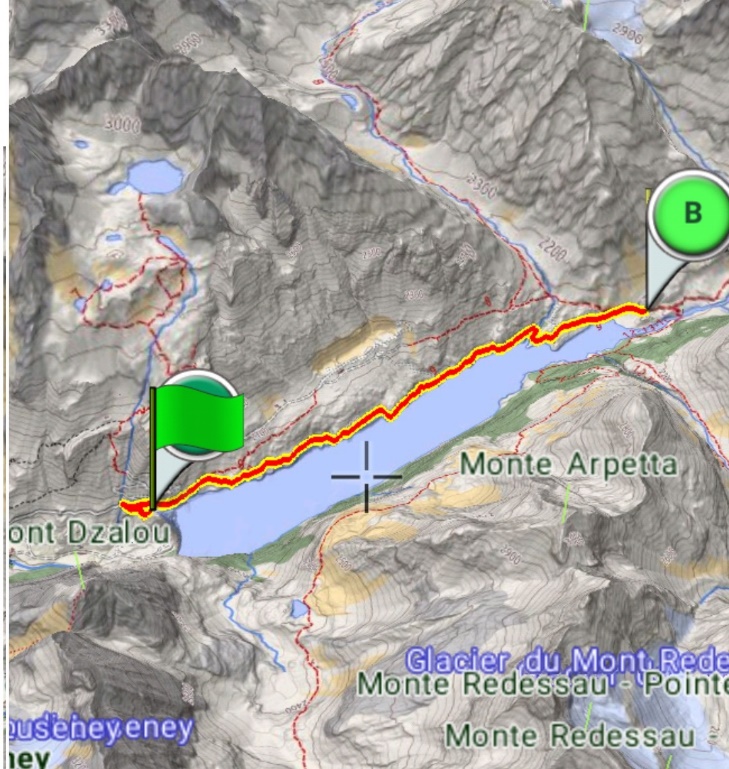
Prarayer Dam
Description: it is the most classic of the walks in Valpelline, along the farm road that leads from the wall of the Place Moulin dam to the village of Prarayer (there is a refuge with the possibility of lunch). To avoid crowds, it is advisable to follow the farm road (which becomes a path halfway) that runs a little further upstream (consult the Europe 3D app).
How to get there: from Thoules take the regional road for Bionaz. Continue to the end of the road, where there are paid parking areas (symbolic cost).
Curiosity: the lake generated by the dam has a unique color, a light blue of rare beauty, due to the suspended glacial sediments. For those with legs, the path continues to the Aosta refuge, from where you can enjoy the glacial views of Valpelline
02
Easy
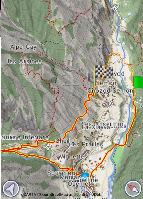
Abbé Henry Loop
Description: Easy walk around Valpelline, for days of uncertain weather.
How to get there: from the house cross the bridge over the Buthier and go down to the right. Immediately take the path on the left near the hamlet of Montcorvé and climb up to the beginning of the wood. Turn right at the electricity line and take the path that runs alongside the Montcorvé wood. After crossing the Arpisson stream, you reach the asphalt road for Arpisson and cross it at the first bend, then descend to Valpelline. Cross the ancient town of Valpelline along the uphill road and take the old mule track to Ollomont. When you reach the fontine deposit, turn right onto the carriage road to a small village (recognizable by the "honey sale" signs. Go up between the houses until you cross the municipal road for Ollomont. Cross it and take path no. 3B for Semon. The long flat path offers a panoramic view of the mountains surrounding Valpelline and a different glimpse of the Buthier valley. Once near Semon, continue towards the Breuson stream along the rockfall valley, cross the Bruson stream on a wooden bridge and continue to the left, level, on a track that is not evident (do not go down towards the houses along the stream!) recently built for the “Tor de Valpelline” foot race. After about 1 km the trail ends on the regional road, near Thoules.
Curiosity: The path is known for being a destination for walks by Abbé Henry (Courmayeur, 10 March 1870 - Valpelline, 1947) was an Italian presbyter, botanist and mountaineer, originally from the Aosta Valley, commonly called Abbé Henry: he became parish priest of Valpelline in 1903 and studied the valley thoroughly, climbed all the surrounding peaks, giving several names to the various peaks. Here is what Abbé Henry tells of the walk: "Afterwards I accompanied the princess [Maria José] on a walk: she wanted to see a little of the Bionaz valley and the Castle of Oyace ... we stretched out on the plain of Montcorvé, where the princess and the lady-in-waiting took pictures [do it too!]. Once in Montcorvé we crossed the Thoules bridge and returned to Valpelline when it was night ”
03
Easy
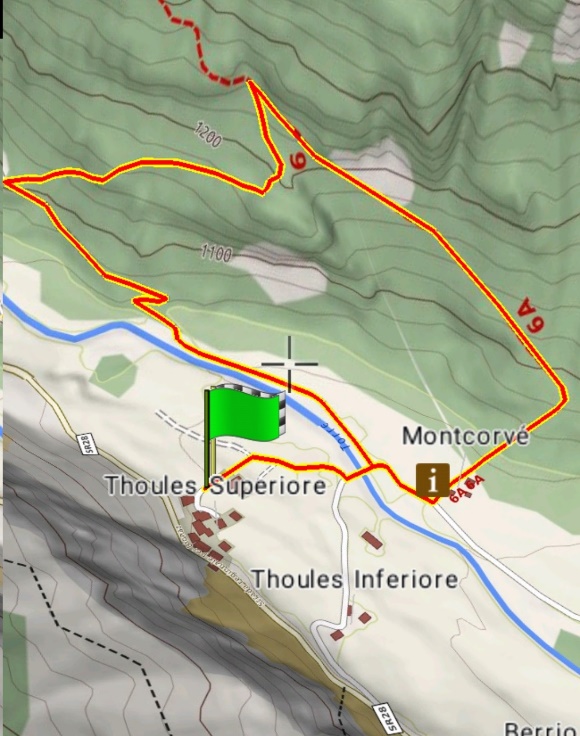
Lower Verzignolettaz Loop
Description: it is a ring in the woods in front of the hamlet of Thoules, a small walk in the cool of the woods.
How to get there: from the house cross the bridge over the Buthier and go down to the right. Immediately take the path on the left near the hamlet of Montcorvé and climb up to the beginning of the wood. Turn left (senitero 6a) as soon as you have entered the woods for a few tens of meters: be careful not to go straight up an old and steep track. After about 20 minutes you will find a fork on the left at a rocky wall: take the path that goes down steeply to a clearing. It is advisable to turn in the clearing, up to its edge, you will enjoy a panoramic view of Thoules and the plain of Montcorvé. From there the path descends to the asphalted road which comfortably reaches Thoules.
Curiosity: why not go around the woods looking for some porcini mushrooms?
04
Medium
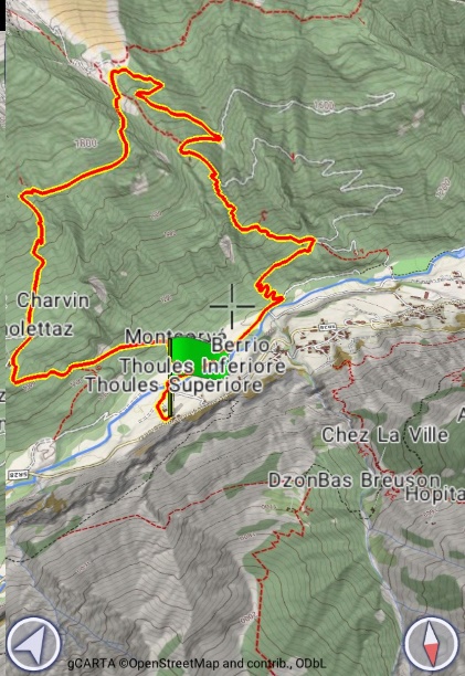
Arpisson–Verzignolettaz Upper Loop
Description: it is a walk first in the woods, then on the grassy slopes of the mountain pastures of Veney and Arpisson and then in the dense forest of Montcorvé, up to Verzignolettaz, the small village leaning on the rocky crags that dominate the plain of Thoules
How to get there: starting from the house, cross the bridge over the Buthier and go down to the right. Once you reach the cable-stayed bridge over the Buthier, take the farm road to the village of Ronceaz: from here take path 5 immediately after the houses, up to the Veney mountain pasture. Path 7 starts next to the pasture on the left as far as Verzignolettaz. From there it is easy to descend to Thoules.
Curiosity: from the Veney mountain pasture you can see the active landslide of the Becca di Viou: it is a landslide caused by the melting of the permafrost, that is, the fossil ice that glues the non-cohesive rock.
05
Hard
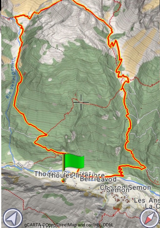
Arpisson–Fouillou High Loop
Description: it is a walk first in the woods, then on the grassy slopes of the Veney and Arpisson pastures and then on the alpine pastures, until reaching Col Fouillou.
How to get there: from the house cross the bridge over the Buthier and go down to the right. Once you reach the cable-stayed bridge over the Buthier, take the farm road up to the village of Ronceaz: from here take path 5 immediately after the houses, up to the Fouillou cross. From there a steep path leads to the hill. From the hill you descend into the long and wild valley of Verzignolaz. After about an hour you will arrive in Verzignolettaz. From there it is easy to descend to Thoules.
Curiosity: from Col Fouillou it is possible to easily reach on the left the Becca di Novailloz, which dominates the plain of Montcorvé and the hamlet of Thoules. In the Verzignolaz valley there is a mountain pasture, so it is possible to see cows grazing and maybe a "bataille", or a bloodless clash between cows to define the hierarchy of the herd.
06
Medium
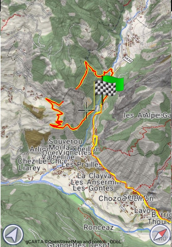
Ru du Mont (from the house)
Description: a fun walk to discover a Ru, or a stream (often of medieval origin) created to carry water towards the sunniest and most arid slopes of the valleys. Don't forget to visit the Chatelair chapel, from where you can enjoy a priceless view.
How to get there: go through the village of Thoules and take the regional road towards Valpelline for about 200 m. Take the path on the right which heads towards Semon. The path, after a short climb, continues flat for several kilometers until you reach the road to Ollomont, which you cross. Go down to the small hamlet of Fressoniaz-dessous (honey sale) and turn right. Before the bridge over the stream, take a paved road that becomes a mule track. The mule track reaches the hamlet of San Cristoforo. From there you go down to the bridge and then go up to the Creton hamlet. From the hamlet, take the steep path no. 8 which in about half an hour will take you to the Ru du Mont estate.
Curiosity: An ancient legend tells that the old Ru des Monts carried water from the valley of Ollomont to the sunny plateaus of Doues, thanks to a daring work of hydraulic engineering that bypassed the steep rocky walls between these two environments. A water guardian (then called "garde-ruisseaux") checked its path every day; in this job he was always accompanied by a white snake, which was actually the animal form of the Fairy that protected the Ru itself. A kind of genius loci, a feminine protective spirit of very ancient origin. When the role of guardian passed to a new person, this, annoyed by the presence of the white snake, killed him. In doing so, he killed the Fairy protecting the fate of the Ru, which immediately began to fill with cracks and to collapse. All attempts to rebuild it since then have failed. Only in 1949, by drilling the mountain with a tunnel that is medium high, a little more than one meter wide and about 800 meters long, was it possible to build the new Ru.
07
Easy
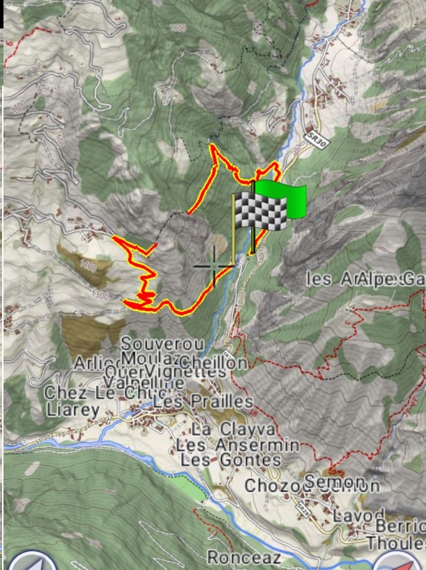
Ru du Mont (from the Fontina House)
Description: a fun walk to discover a Ru, or a stream (often of medieval origin) created to carry water towards the sunniest and most arid slopes of the valleys. Don't forget to visit the Chatelair chapel, from where you can enjoy a priceless view.
How to get there: go to the Fontina house (road to ollomont) and park. Returning back to the asphalted road, after the bridge over the stream, take a road on the left that was initially paved and becomes a mule track. The mule track reaches the hamlet of San Cristoforo. From there you go down to the bridge and then go up to the Creton hamlet. From the hamlet, take the steep path no. 8 which in about half an hour will take you to the Ru du Mont estate.
Curiosity: An ancient legend tells that the old Ru des Monts carried water from the valley of Ollomont to the sunny plateaus of Doues, thanks to a daring work of hydraulic engineering that bypassed the steep rocky walls between these two environments. A water guardian (then called "garde-ruisseaux") checked its path every day; in this job he was always accompanied by a white snake, which was actually the animal form of the Fairy that protected the Ru itself. A kind of genius loci, a feminine protective spirit of very ancient origin. When the role of guardian passed to a new person, this, annoyed by the presence of the white snake, killed him. In doing so, he killed the Fairy protecting the fate of the Ru, which immediately began to fill with cracks and to collapse. All attempts to rebuild it since then have failed. Only in 1949, by drilling the mountain with a tunnel that is medium high, a little more than one meter wide and about 800 meters long, was it possible to build the new Ru.
08
Easy
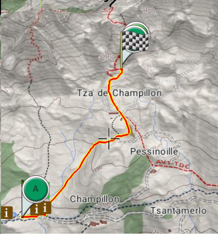
Champillon Refuge
Description: The Champillon Adolphe Letey refuge, inaugurated on 3 July 2005, is located at an altitude of 2465m upstream from the Tza di Champillon mountain pasture on a panoramic hill from which you can enjoy a beautiful view of the Ollomont valley and the Lower Valpelline. It takes its name from the historic first citizen of Doues, Adolphe Letey, mayor from 1951 to 1990. His idea and his merit for having always believed and invested in the importance of tourism in small realities like that of Doues.
How to get there: Stopping your car at Plan Detruit at 2000 meters above sea level, you can access the refuge after a short walk through the path that winds for about an hour through the woods and mountains of the Champillon basin, making the refuge an ideal destination for all types of users (professional hikers, families and children).
Curiosity: the refuge hosts temporary art exhibitions and is equipped with wi-fi and a Sauna & Hot Tub. Before descending, we recommend that you go up to the Tibetan viewpoint (visible from the refuge a 5-minute walk away) and go down on the other side of the viewpoint to the ephemeral lake (without a name).
09
Easy
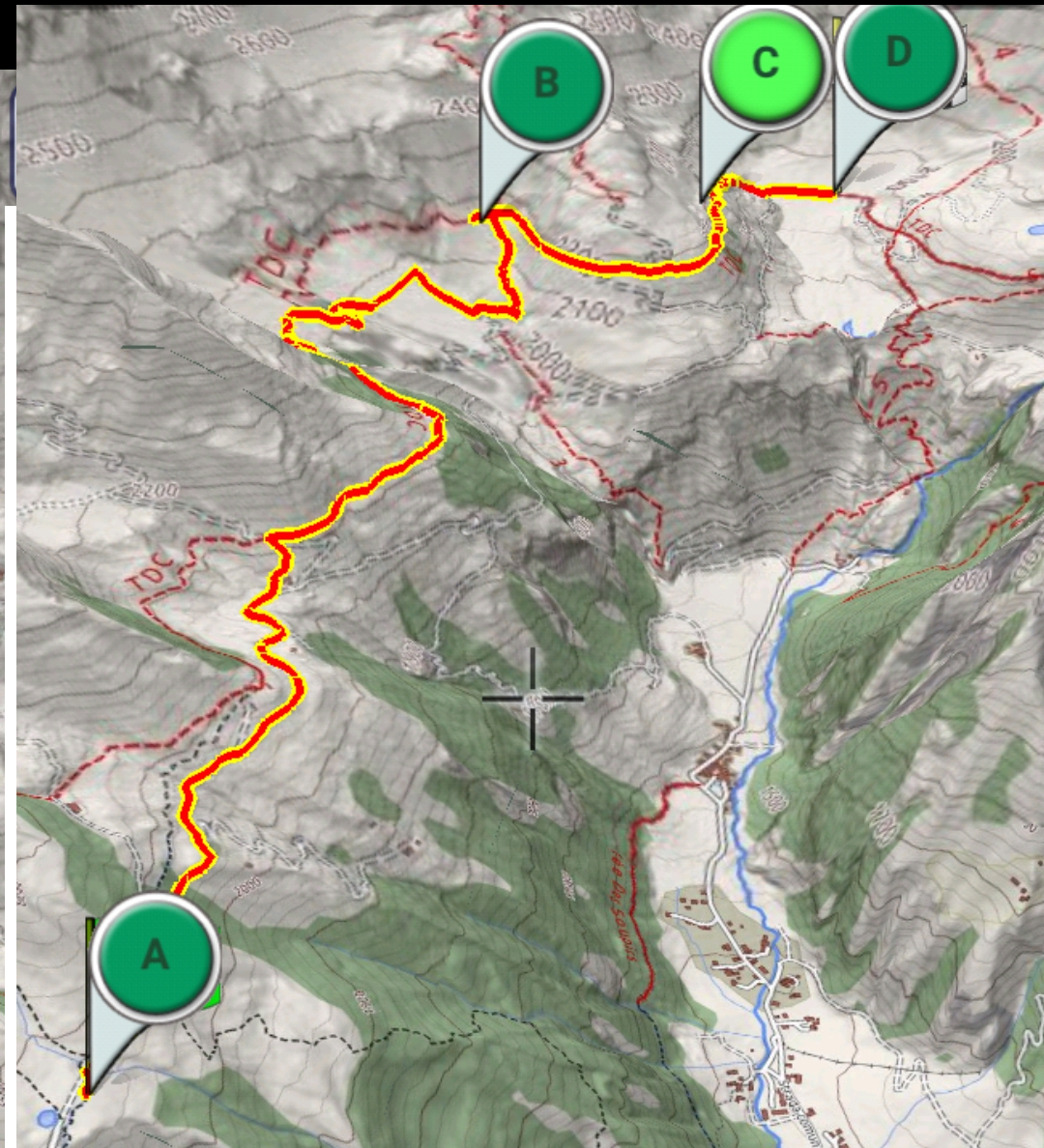
Ru de By from Champillon
Description: The Ru de By allows, safely and with relatively little physical effort, to have an excellent view of the Conca di By, the mountains of the Central Valley and the majestic Grand Combin. The itinerary, although it has a very low altitude difference, is 19.2 km long (round trip) but since the return takes place on the same path as the outward journey, it can be interrupted at any time.
How to get there: By stopping with your car at Plan Detruit at 2000m of altitude, you can easily access the Ru, as it starts about 200m from the parking lot on the left of the farm. Ru de By is an ideal destination for families with children.
Curiosity: the Ru, of ancient origin, brought water to the sunny meadows of Doues from the By basin, rich in water but cold and hardly cultivable. The Aosta Valley is rich in water, but the summer rainfall is very modest and therefore many canals (Ru) were built for irrigation to make the sunny and arid slopes productive.
10
Hard
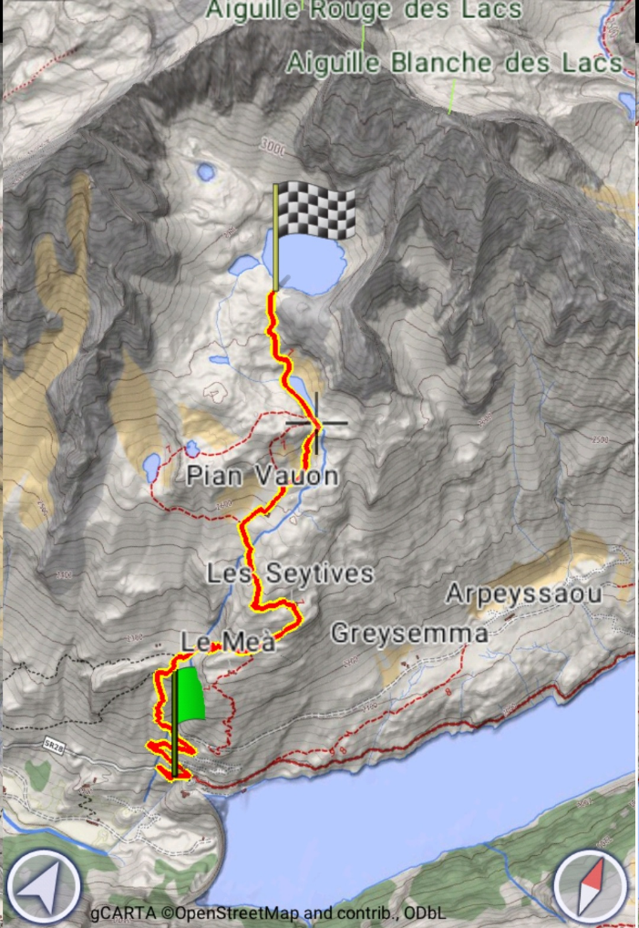
Lac Mort
Description: the trip to Lac Mort is one of the trips we recommend to hikers who want to get to know the upper Valpelline. It is a balcony overlooking the valley, with unique glimpses and panoramic views. The palette of colors that make up the natural sceneries along the way are truly unique.
How to get there: From the square of the Place Moulin dam (1969 m), take the dirt road that rises to the left. Follow it up to the third bend, where it branches off to the left. the path that climbs in a zigzag manner on the steep slope. You reach the ledge that houses the abandoned huts of La Mea (2320 m). From here you have to go right, cross a stream and enter a small valley bordered by modest rock walls. At its end you come out on a panoramic shoulder on the dam. Continue along the ridge, meeting a stretch of paved path before touching the Seytives huts (2455 m). The path bends to the left passing close to a cairn of stones, approaches the stream that it runs along for a short distance, then crosses it to reach the Plan Vayun mountain pasture (2578 m - now under renovation). We then tackle a diagonal to the right to approach and skirt the emissary stream, up to Lac Long (2720 m). Along its left bank you reach the tributary and then the grassy slope where the path climbs towards the stony ground. In short you touch the shore of Lac Mort (m. 2843).
Curiosity: A wall of reddish rocks completely surrounds the valley where the lake rises: the reflections that arise from it give the lake shades of color ranging from red to blue. Someone called it "the most beautiful ugly place in the Aosta Valley". In two words exactly opposite there are all aspects of this short excursion. The bleak scenery where this indigo eye is located and the absolute grandeur of the views offered to get up here. The crown that surrounds it has the charm of the real mountain range, with imposing walls and bright colors with the violent contrast of the clear sky.
11
Medium
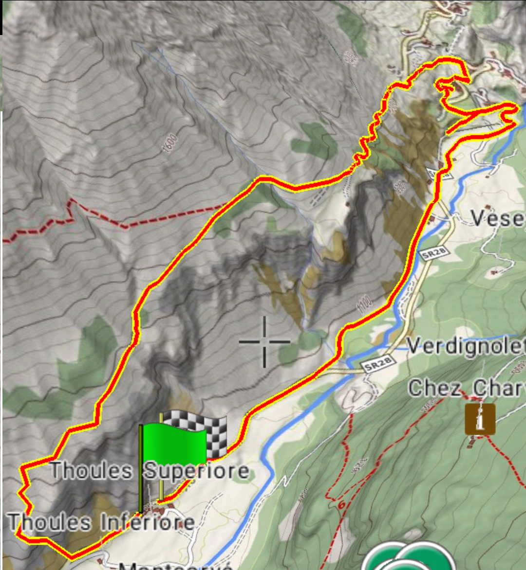
Thoules–Oyace Loop
Description: an unusual route, not very popular, to be covered uphill, downhill (you need a transport) or in a loop. It is a journey through wild places, but also among the inhabited hamlets of Oyace.
How to get there: go through the village of Thoules and take the regional road towards Valpelline for about 200 m. take the path on the right that heads towards Semon. The path, after a short climb, forks: take the left branch, not too obvious at a clearing (located on the left). Get help from the Europe 3D app or the map shown here. The path climbs up the rocky crags overlooking Thoules. The path winds through the fir and pine forest and climbs steeply up the coast. Towards an altitude of 1460 the path descends to the farm that leads to the telecommunication antennas (interesting panoramic point). The farm returns to the asphalted road that runs up to Veyne. From there on the old mule tracks you descend towards the valley floor and then take the old road (orographic right) up to Thoules.
Curiosity: you could find a deer stage in the woods: it is in fact in these areas that the deer leave their decks at the end of the mating season.
12
Hard
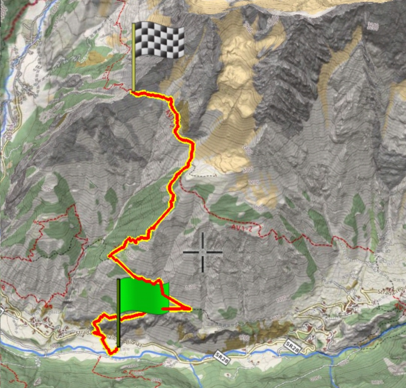
Col Bruson
Description: A “vertical” in the wilderness, for those with good legs.
How to get there: go through the village of Thoules and take the regional road towards Valpelline for about 200 m. Take the path on the right which heads towards Semon. The path, after a short climb, forks: take the left branch, not too obvious at a clearing (located on the left). Get help from the Europe 3D app or the map shown here. The path climbs up the rocky crags overlooking Thoules. The path winds through the fir and pine forest and steeply climbs the coast, from there take the fork to the left (attention not evident, be guided by the Europe 3D application). Alternatively, from home to reach the town of Semon. From the center of the village take the path that climbs into the valley.
Curiosity: the Col Bruson is one of the most difficult passages of the extreme trail race "Tor de Geants": the competitors avoid as much as possible to spend the night, because the descent on Ollomont is very demanding.
13
Medium
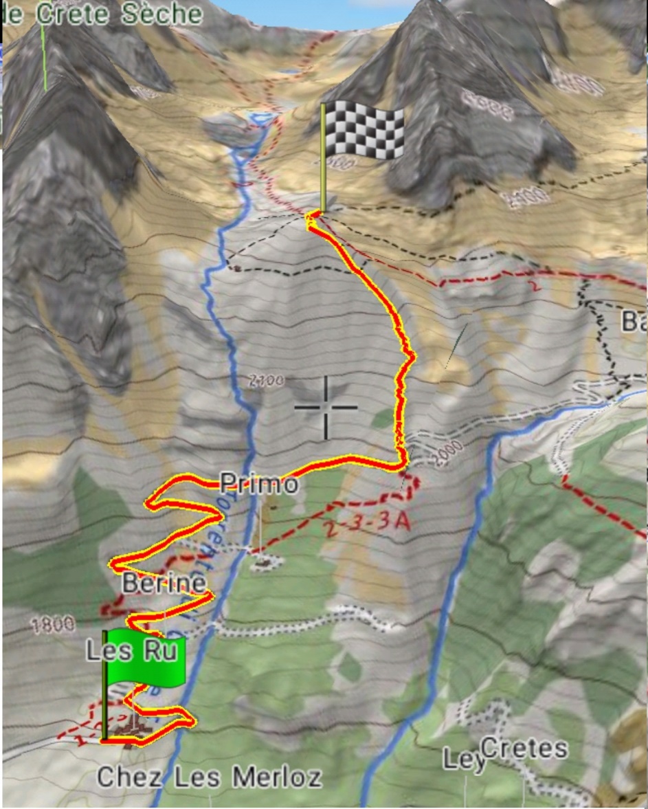
Crête Sèche Refuge
Description: The Crête Sèche refuge is located at 2,410 meters above sea level and boasts a breathtaking view of the Bionaz valley: it is surrounded by the suggestive Morion chain, characteristic for its jagged peaks. You can have lunch according to the Aosta Valley tradition in a convivial atmosphere, typical of the mountain environment
How to get there: take the regional road 28 to Bionaz. From the Ruz car park, continue on foot along the farm road to the Berrier pasture, where you will find the signs for the refuge. The path is traced and there are multiple signs along the path
Curiosity: The structure is an ideal base for mountaineering and climbing enthusiasts, but also an excellent destination for families and hiking enthusiasts.
14
Medium
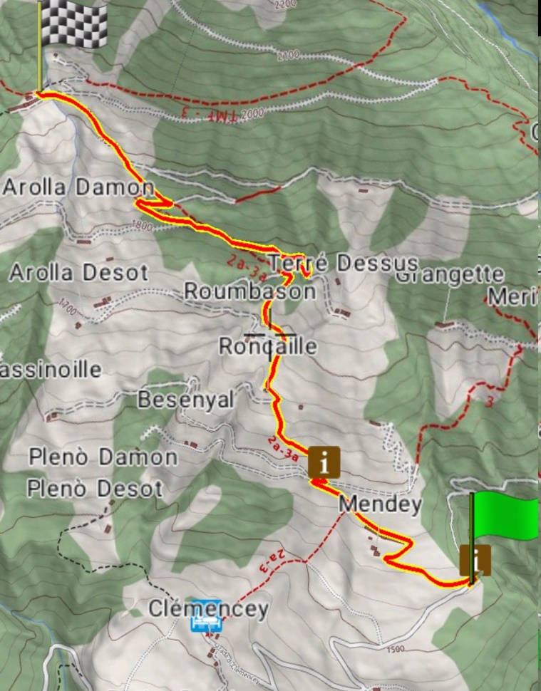
Chaligne Refuge
Description: the refuge is an excellent destination for families with children. Outside there is a small lake with a stream and waterfalls perfect for children's water games.
How to get there: proceed by car to Buthier di Gignod (about 15 minutes). From the hamlet of Buthier you reach Alpe Mendey and further on you take the path "3A" (travel time 1.15 h). The refuge can also be reached by mountain bike (5 km along the rural road)
Curiosity: From the refuge it is possible to take various walks both towards the mountain pastures, following guided itineraries that will allow guests to get to know the rural reality of the area better; and towards the surrounding woods, which are rich, as in general throughout the Gran San Bernardo Valley, of fauna and flora varieties with very particular aspects compared to the other Valle d'Aosta valleys. The morphology of the head of the valley allows various species of mammals to enjoy convenient access for migrations from neighboring Switzerland. Some groups of animals, in particular cervids, have also settled well on the Italian side. As regards the avifauna, on the other hand, especially in the spring and autumn pass, species that are completely unusual for the Alpine sector can be observed.
15
Hard
Frassati Refuge
Description: The Frassati Refuge is located at 2,542 m a.s.l., in the immediate vicinity of the lakes called “Lac des Merdeux”. It is located in the basin of the same name downstream of the Col Tapie, at the intersection of the Alta via n.1 route that leads to the nearby Col Malatrà with the "Tour du Grand Saint Bernard" route. It was built by the guys from Operation Mato Grosso between 2008 and 2011. Read the story. In 2011 it was inaugurated and dedicated to Blessed Pier Giorgio Frassati.
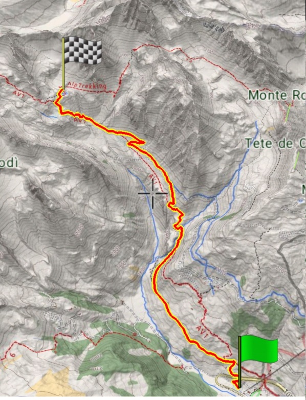
How to get there: drive to the car park of the Crevacol ski lifts (20 minutes by car from Thoules). the ascent itinerary follows the route of the Alta via n.1 from Saint Rhemy en Bosses. Alternatively, you can reach Arp du Jeu by car, at an altitude of 2002 m, where the arrival station of the first section of the chairlift of the Crevacol lifts is located. From here, continue west along the farm road that climbs to the Tza de Merdeux mountain pasture, at an altitude of 2273 m, initially flat and then gently sloping. From the mountain pasture, continue on the Alta Via path n.1 and in less than an hour you will reach the Frassati Refuge.
Curiosity: The construction works of the Frassati Refuge began in the summer of 2008 by the young people of Operation Mato Grosso, a movement of young people from all over Italy, who worked for free for three summers, until the inauguration in 2011. The transport of the necessary materials was done almost entirely on the shoulders of the boys, who gave one or more weeks of their summer holidays to build the refuge. Immersed in nature, in the silence of the mountain, away from the noise of the city, choosing to give time away for the poorest, living the weeks following the natural rhythm of the day, from sunrise to sunset: these are the secret ingredients of the Refuge. In line with the spirit of adventure and essentiality of Operation Mato Grosso, the boys lived the weeks of work using the Tza di Merdeux mountain pasture as a base camp, located 45 minutes' walk below the refuge.
16
Easy
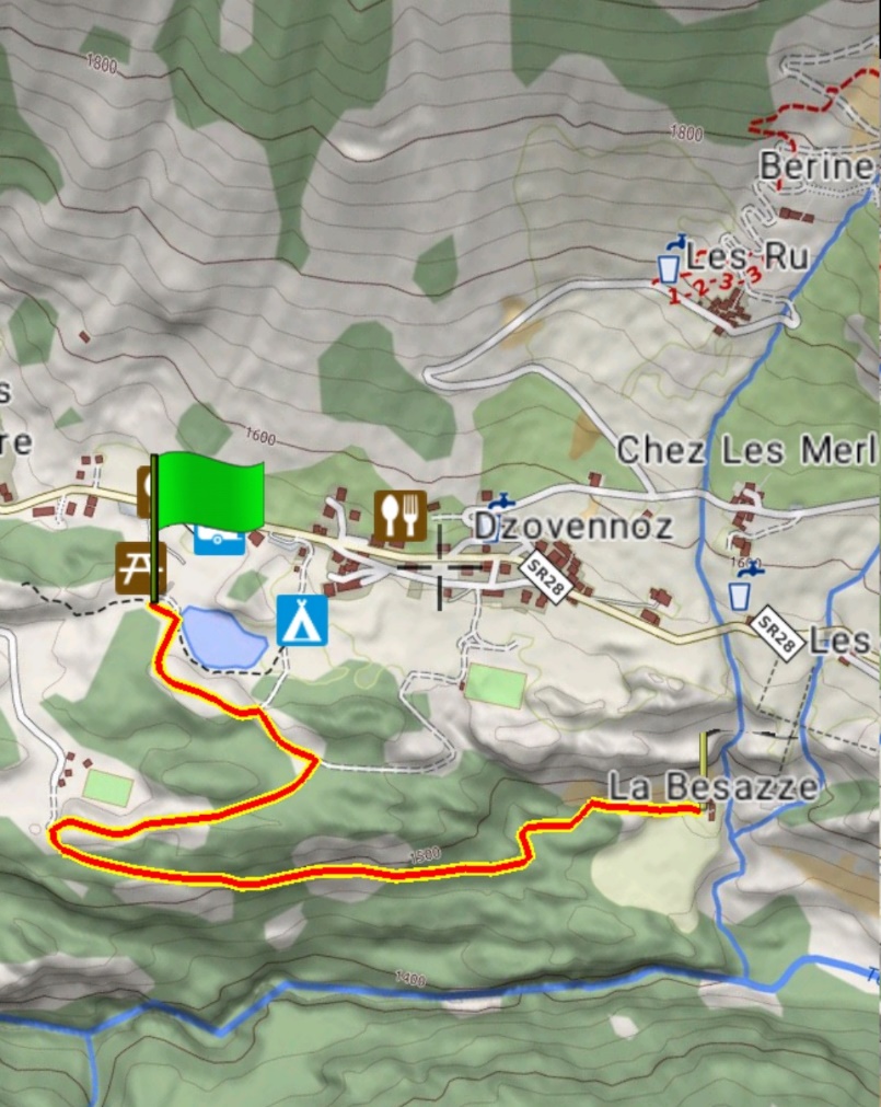
Bionaz Mines Loop
Description: along the Nordic ski slopes on easy dirt roads you reach the Besazze huts. From there in a few minutes you can reach the ancient mining center.
How to get there: by car to the Lexert di Bionaz lake. From there follow the signs. Attention at the first fork go right. Once the visit is over, it is advisable to go up to the regional road and return to the lake first along the road and as soon as possible, along the Nordic ski slopes, passing by the biathlon stadium.
Curiosity: the copper mine was mainly cultivated in the twentieth century but was probably already exploited in previous centuries. You can collect the yellow and orange stones to make charms.